 |
SNOWPACK 20260725.8e81d051
Physically based, energy balance snow cover model
|
|
SNOWPACK 20260725.8e81d051
Physically based, energy balance snow cover model
|
The configuration for a given simulation is kept in a ".ini" file (see http://en.wikipedia.org/wiki/INI_file). This is an ascii file that contains keys/values structured by sections. This can be easily edited with a simple text editor. More information about the structure of the file and how to generally deal with it can be found in MeteoIO's documentation (section "How to build your io.ini configuration file"). However, it is recommended to use the inishell tool for generating the configuration file for Snowpack in order to prevent missing important keys, etc Please read MeteoIO's documentation (specially the "general Concepts" introduction)!
It is highly recommended to use the Inishell tool to generate these ini files in order to reduce editing errors. This tool also allows you to edit an existing file in order to change the configuration.
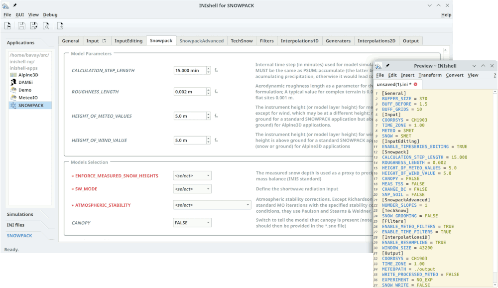
Each ini file section is shown in a separate tab, each key on its own line. Keys that appear in red are mandatory and will trigger a warning box if trying to visualize/save an ini file before providing a value for these keys. A help text describing the key is shown on the right. Once all has been configured, the configuration can be saved to an ini file, ready to be interpreted by Snowpack.
The configuration files being an ascii format (INI format), it is possible to manually copy/paste whole sections of such files between simulations in order to run similar simulations without the need to re-type the whole configuration. It is also possible to use inishell in order to find out which keys are available, which values they can take and what they mean and manually type them in an existing ini file.
The Snowpack_advanced section contains settings that previously required to edit the source code and recompile the model. Since these settings deeply transform the operation of the model, please refrain from using them if you are not absolutely sure of what you are doing.
When selecting WATERTRANSPORTMODEL_SOIL = RICHARDSEQUATION, the grain size (rg) of the soil layers in the *.sno file is used to determine the water retention properties of the soil, according to the following values:
| Soil type | rg | Soil type | rg |
|---|---|---|---|
| ORGANIC | 0.2 | SANDYCLAYLOAM | 6.5 |
| CLAY | 0.5 | SANDYLOAM | 7.5 |
| CLAYLOAM | 1.5 | SILT | 8.5 |
| LOAM | 2.5 | SILTYCLAY | 9.5 |
| LOAMYSAND | 3.5 | SILTYCLAYLOAM | 10.5 |
| SAND | 4.5 | SILTLOAM | 11.5 |
| SANDYCLAY | 5.5 | WFJGRAVELSAND | 12.5 |
Notes: